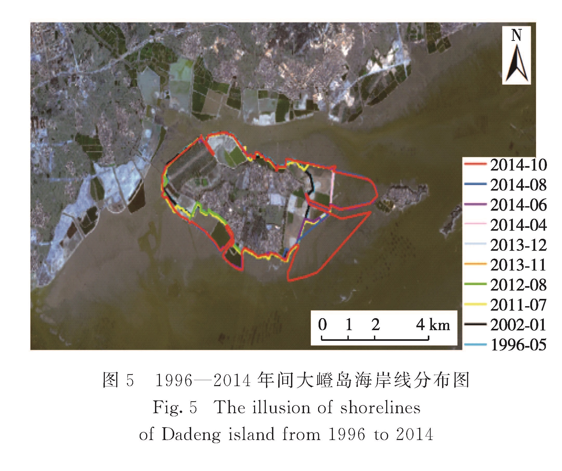
3.1 大嶝岛岸线变迁
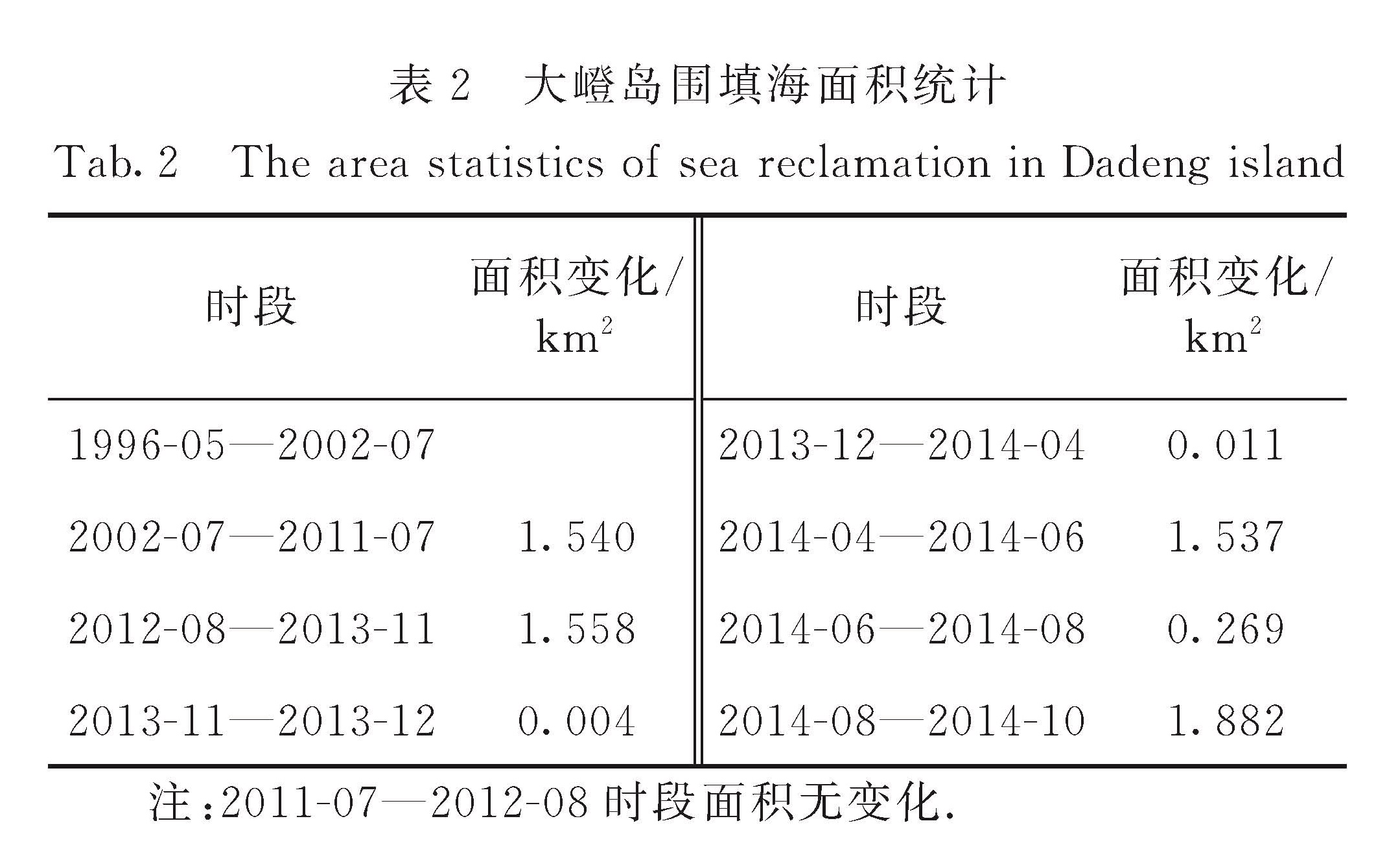
图5为利用遥感影像提取的1996—2014年间大嶝岛的岸线变迁图像.可以看出,1996—2011年间大嶝岛岸线变化主要以西南和东北部的扩张为主,统计数据表明这一时期大嶝岛面积增加1.54 km2(表2).其中,1996—2002年间大嶝岛海岸线变化不大,但2002—2011年间,大嶝岛的东北岸线变化较为明显(图5).
为推进厦门岛内外一体化,2013年12月大嶝岛获准填海.从图5可以看出:2012年8月到2013年12月,大嶝岛东部的海岸线并未发生太大变化; 而2014年初东北部开始出现围堰,导致东部海岸线向外海扩张; 至2014年10月已基本可以看出大嶝机场规划的区域形状.可见,导致大嶝岛岸线变化的主要原因一是养殖围填,二是新机场围填海建设.
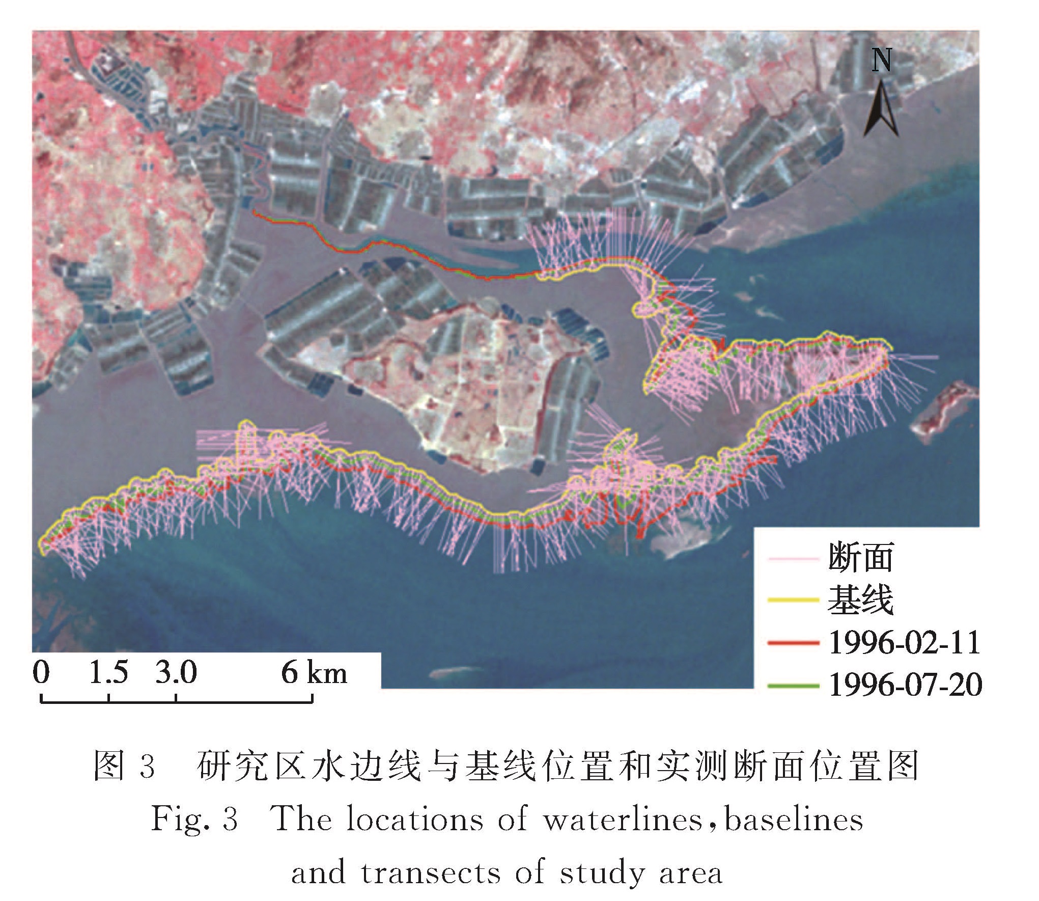
图5 1996—2014年间大嶝岛海岸线分布图
Fig.5 The illusion of shorelines of Dadeng island from 1996 to 2014
表2 大嶝岛围填海面积统计
Tab.2 The area statistics of sea reclamation in Dadeng island
3.2 大嶝岛潮滩的冲淤变化
根据大嶝岛周边潮滩形态的时空变化特征,将其分为西部、西南部、南部、东部和北部5个区(图1).分析所获得的遥感影像,发现低潮时大嶝岛西部的滩面露出,与翔安蔡厝附近的潮滩相连,两者难以区分; 而大嶝岛东部在低潮时与小嶝岛西部的潮滩相连接,潮滩坡度难以计算; 大嶝岛北部在低潮时也有成片滩面露出,只剩“S”型潮沟,而且该潮沟沟坡陡峭,潮沟宽度比较小.鉴于获得的遥感影像数量较少,所对应的潮位不足以适用本文中方法的计算,因此本研究主要以大嶝岛西南和南部为主来分析潮滩的淤涨和沉积变化,计算结果如表3所示.
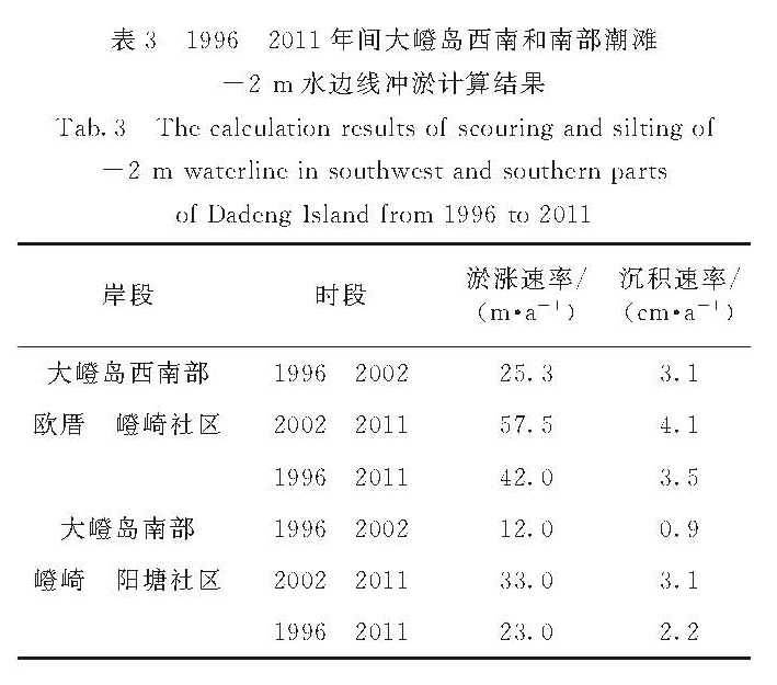
表3 1996—2011年间大嶝岛西南和南部潮滩-2 m水边线冲淤计算结果
Tab.3 The calculation results of scouring and silting of -2 m waterline in southwest and southern parts of Dadeng Island from 1996 to 2011
从表3可以看出:1996—2011年间,大嶝岛西南部同一潮位的水边线主要是向海推进,计算表明其平均淤涨速率为42 m/a,沉积速率为3.5 cm/a; 分阶段来看,无论淤涨速率还是沉积速率,2002—2011年间均大于1996—2002年间,可见相较于20世纪末,近10年来大嶝岛西南部的潮滩淤积更为严重了; 和大嶝岛西南部相比,其南部的淤涨速率和沉积速率较小,但近10年的淤涨速率和沉积速率也是明显大于20世纪末,分别从12 m/a和0.9 cm/a增加到33 m/a和3.1 cm/a.
研究表明,大嶝岛西南和南部海域一直处于弱水动力环境的缓慢沉积状态[15],其沉降通量大于侵蚀通量,总体上以淤积为主[16].悬浮泥沙主要由大嶝岛南部水道向大嶝岛西南部近岸浅滩输运,且输运量较大,而经该浅滩继续往西北方向的悬沙输运量比较少,利用210Pb年代学分析结果可知大嶝西南部海域是沉积速率最大的地方,平均沉积速率可达3.9 cm/a[17].本研究利用遥感资料统计分析得到的沉积速率基本与该速率一致.
近10年来大嶝南部和西南部海域的淤积速率增加,与近年来大嶝海堤的建设活动和高强度的围填海活动有关.大嶝海堤完工建设于20世纪90年代初,其建设阻碍了绕大嶝岛的水流,从而明显改变了该地区的水动力和泥沙输运,进而加速了大嶝岛西部和西南部近岸浅滩的输运过程.21世纪初以来,大嶝岛及其周边地区进行了一系列围填海活动,导致大量泥沙人为入海,改变了原有的水沙平衡状态,从而影响到岸滩剖面的发育过程,明显加速了大嶝岛潮滩的淤积过程.
3.3 大嶝岛潮滩面积变化
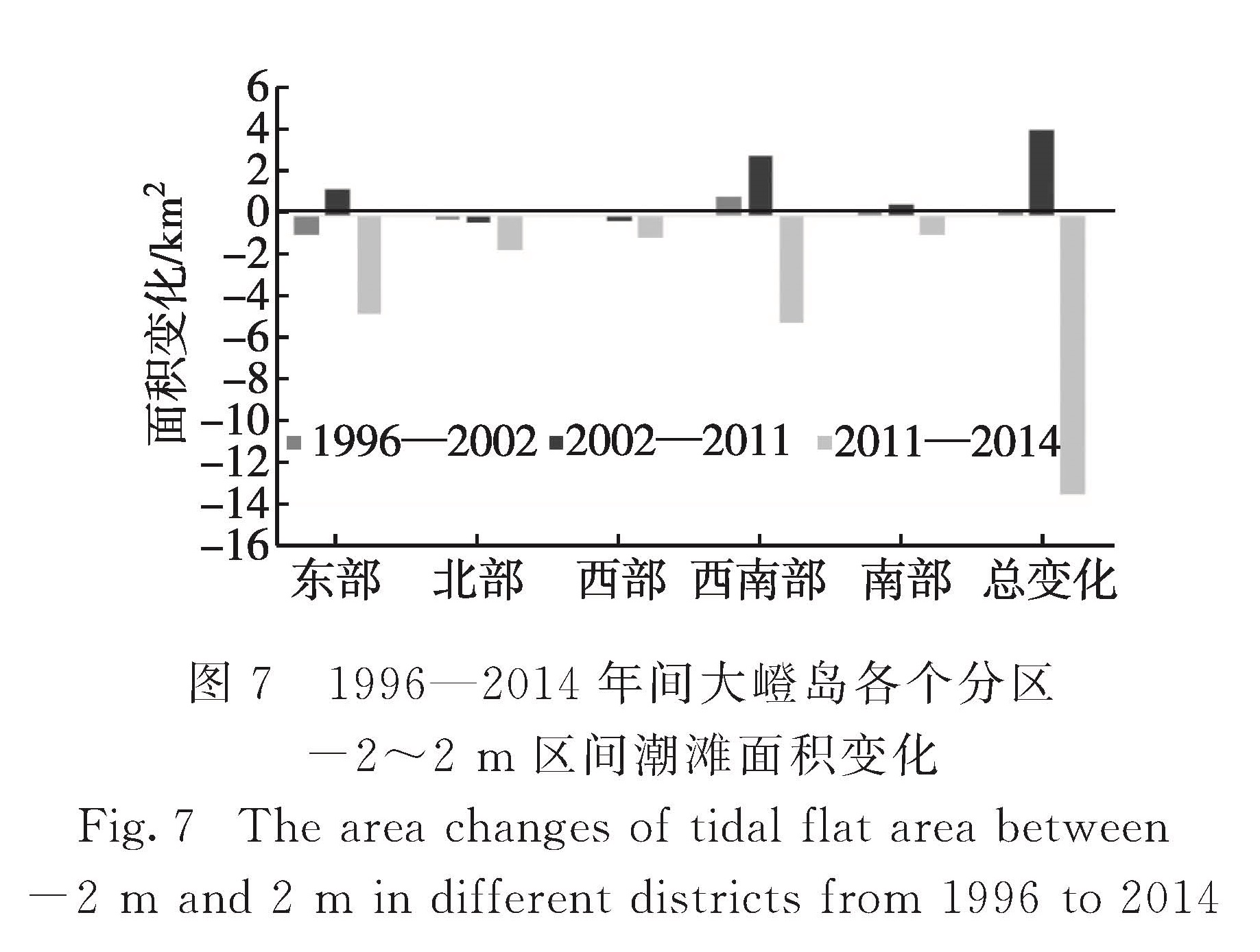
图6给出了1996—2014年间大嶝岛周边-2~2 m区间潮滩面积的变化情况.总体上,大嶝岛该区间潮滩面积在1996—2011年间不断增加,尤其是2002—2011年间,面积增加了4.19 km2; 与1996年相比,2011年面积增加了约16%; 而在2011—2014年间潮滩面积却大幅度减少,减少的面积约13 km2,2014年比2011年减小了约41%.分区域来看,1996—2002年间,大嶝岛的东部和北部面积有所减少,其他区域增加.2002—2011年间各区面积的变化趋势也有所差异,其中北部和西部面积有所减少,其他区域增加,其中增加最多的是西南部海域,其次是东部海域; 而2011—2014年间各区域面积均为减少,面积减小最大的区域是西南部海域,其次是东部(图7).可见,自2002年以来,大嶝岛-2~2 m区间潮滩面积变化最为明显的海域是西南部和东部海域.
图6 1996—2014年间大嶝岛-2~2 m区间潮滩面积变化
Fig.6 The area changes of tidal flat between -2 m and 2 m from 1996 to 2014
图7 1996—2014年间大嶝岛各个分区-2~2 m区间潮滩面积变化
Fig.7 The area changes of tidal flat area between -2 m and 2 m in different districts from 1996 to 2014
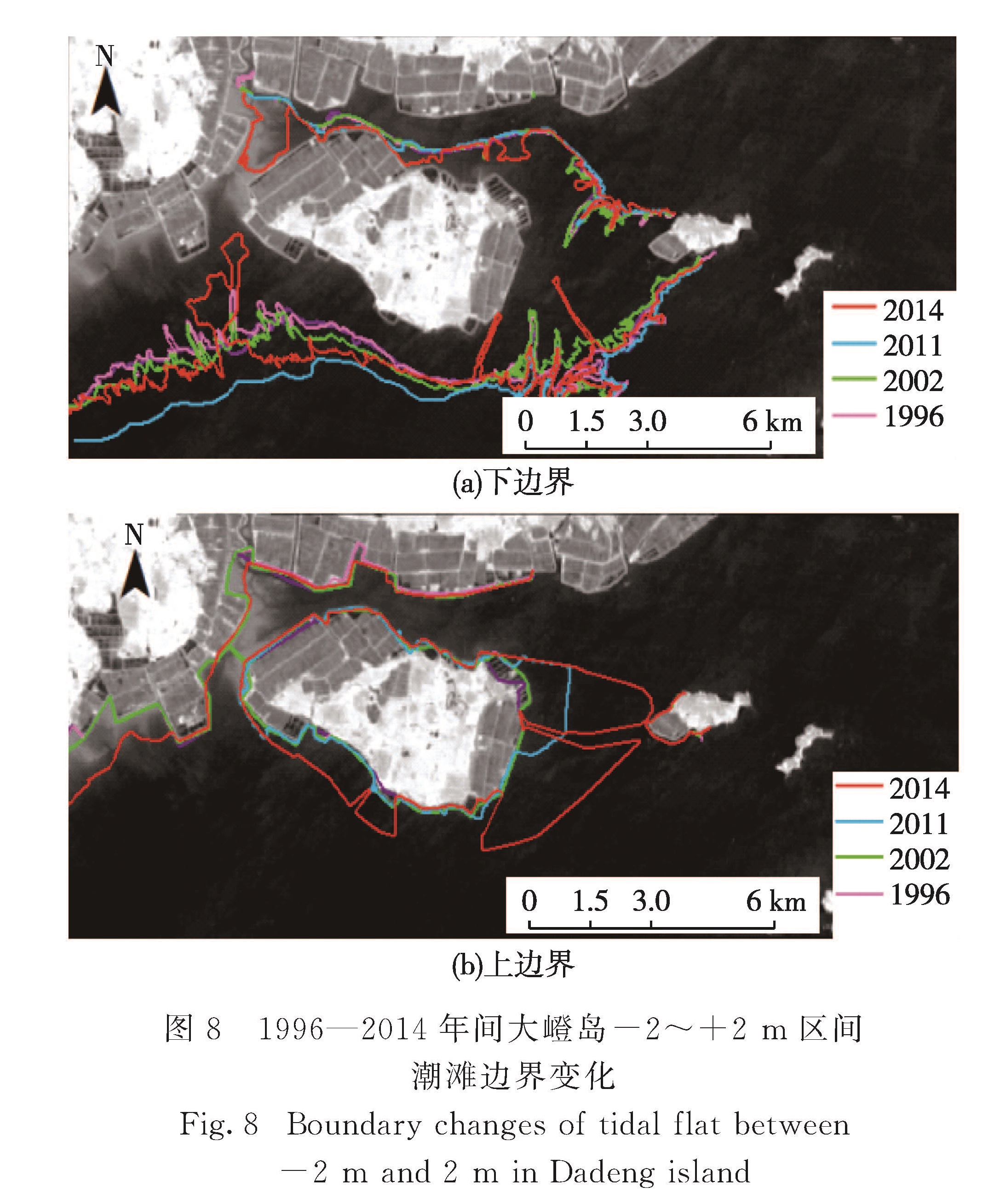
潮滩面积的变化与上、下边界的变迁息息相关,上边界向海移动导致面积减少,下边界向海移动导致面积增加,当上边界向海方向变化速率大于下边界向海的淤积速率时,潮滩面积减少,反之面积增加.由表3可知,大嶝岛西南和南部海域在2002—2011年间的淤积速率最大.受此影响,2011年该区间潮滩下边界的水边线比2002年更靠外海(图8(a)),尤其是西南部的欧厝外海,与2002年相比,2011年的水边线向外海移动了约500 m.尽管在此期间,这些区域的海岸线因围填海影响也向海移动,但其变化速率小于下边界向海移动的速率,因此1996—2011年间大嶝岛的-2~2 m区间潮滩面积逐渐增加(图6),并以西南部增加最为明显(图7).
从图5和图8(b)可以看出,2011—2014年大嶝岛潮滩上边界向海扩张与近几年该区域不断的围填海活动是一致的,尤其是在2013年大嶝国际机场获批填海后,2013年11月至2014年10月整个岛屿的围填面积高达3.70 km2,其围填区主要位于大嶝岛的东部,部分位于西南部,这些活动导致其东部和西南部的潮滩面积在2011—2014年间减少最多.此外,2008年厦门市开始实施的厦门海域清淤整治工程也使潮滩的下边界向海岸方向移动,导致该区间潮滩面积减少.从图8(a)可以看出,2014年西南部和北部潮滩下边界的水边线比2011年更靠近海岸,且形态发生了很大的改变,2011—2014年间大嶝岛的-2~2 m区间潮滩面积以西南部和东部海域最为明显(图8).可见人为活动对于大嶝岛潮滩面积变化有非常重要的影响.
图8 1996—2014年间大嶝岛-2~+2 m区间潮滩边界变化
Fig.8 Boundary changes of tidal flat between -2 m and 2 m in Dadeng island

![图2 基于三角形理论的潮滩坡度和基准潮位水边线校正示意图[16]<br/>Fig.2 The illusion of beach slope calculation and waterlines correction based on the equiangular triangle theory[16]](2018年01期/pic84.jpg)